
Key Takeaways:
- The fundamental driver: Tropical weather is driven by localized convective instability—intense heat and moisture—rather than the synoptic frontal systems that dominate temperate-latitude forecasting.
- The scale of a storm: A single convective cell in Southeast Asia typically spans 2 to 10 kilometres in diameter and completes its full lifecycle—from the first cumulus cloud to total dissipation—in well under 90 minutes.
- Micro-triggers dictate impact: Land-sea breeze convergence and urban heat islands mean two neighbourhoods a few kilometres apart can experience completely different weather at the exact same moment.
- The limits of numerical models: Standard numerical weather prediction (NWP) models cannot resolve storms this small or fast. Even high-resolution "convection-permitting" models (running at 1–4km grids) struggle with the physics of isolated tropical cells. This resolution gap is precisely why hyperlocal, 100m-resolution nowcasting is a baseline requirement for operations in the region.
Why is a forecast that works perfectly well for a logistics fleet in London or Chicago practically useless for a delivery operation in Jakarta or Singapore?
The answer is not a lack of data, nor is it poorly written software. The answer lies in atmospheric physics. Southeast Asia operates in a completely different meteorological regime than Europe or North America, driven by phenomena that are physically smaller, vastly faster, and exponentially more intense than temperate weather.
For technical evaluators and product teams building routing engines, supply chain automations, or safety protocols, understanding the mechanics of tropical convection is the first step in procuring weather data that actually works.
1. Why the Tropics Don't Run on Fronts
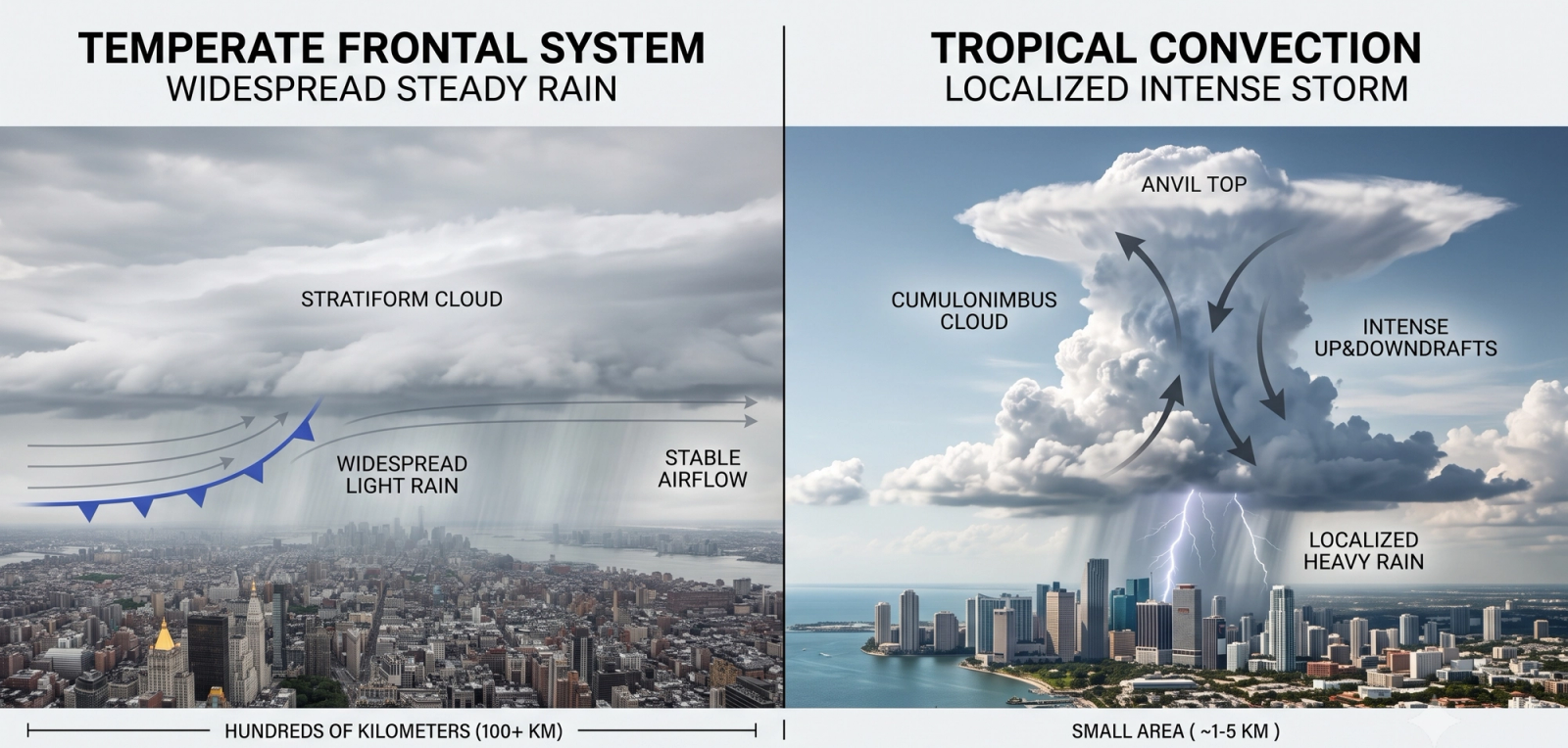
Most global forecasting models were historically designed by and for mid-latitude nations. Temperate-latitude weather is primarily driven by baroclinic instability—the boundaries (fronts) where cold, dry polar air masses collide with warm, moist tropical ones. This collision produces the wide, slow-moving bands of steady rain familiar to a North American autumn or a European winter. Because these frontal systems stretch for hundreds of kilometres and take days to move across a continent, coarse global grids can predict them with high accuracy days in advance.
The tropics do not have this mechanism. Near the equator, temperature and atmospheric pressure barely vary from day to day or from place to place. There is rarely a sharp air-mass boundary to track.
Instead, tropical rainfall is driven by convective instability. Intense equatorial solar radiation rapidly heats the land or sea surface. This causes the hot, highly humid air immediately above it to rise. As this buoyant air ascends, it cools and condenses into towering cumulonimbus clouds. Broad-scale features like the seasonal monsoon establish the background moisture supply, effectively raising or lowering the general odds of a storm on any given day. But they do not dictate where or when a specific storm will initiate. That is decided locally, hour by hour.
2. The Life of a Convective Cell
To understand why traditional weather APIs fail in Southeast Asia, you must understand the lifespan of a convective cell.
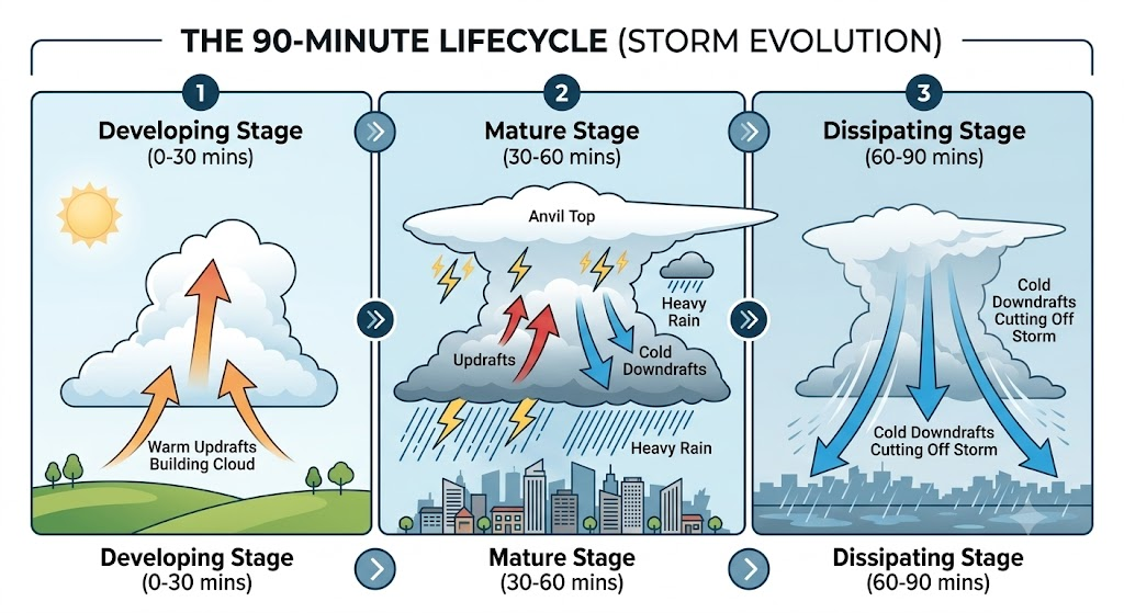
A standard tropical convective cell follows a violent, highly compressed arc:
- Developing Stage: Cumulus clouds build rapidly through the mid-morning as surface heating increases. Updrafts dominate.
- Mature Stage: By early-to-mid afternoon, the cloud matures into a massive cumulonimbus anvil. Rain begins to fall, creating a strong downdraft. Heavy precipitation and lightning peak.
- Dissipating Stage: The storm's own cold downdraft hits the surface and spreads outward (a "cold pool" or gust front), effectively cutting off the warm, moist updraft that was feeding the storm. Without its fuel, the storm collapses.
The physical diameter of one of these cells is usually just 2 to 10 kilometres. Its total lifecycle—from initiation to dissipation—is commonly 30 to 90 minutes.
This is the physical reason a city-wide forecast of a "60% chance of rain" is meaningless for operational routing or construction scheduling. The storm you are trying to avoid is a moving, rapidly evolving object smaller than most planning districts, with a lifespan shorter than a typical driver's shift.
3. Local Triggers That Create Hyperlocal Variability
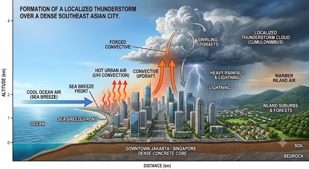
Layered on top of this basic convective cycle are micro-triggers that determine exactly where a storm initiates.
Land-sea breeze convergence is the clearest example in coastal Southeast Asian cities. As land heats up faster than the ocean during the day, the sea breeze pushes inland. When this maritime air meets opposing prevailing winds or storm outflow boundaries inland, it creates a convergence line. This invisible boundary forces air upward, making it the exact corridor where deep storms preferentially form.
Urban Heat Islands (UHI) alter the picture further. The dense, paved cores of cities like Kuala Lumpur, Bangkok, and Ho Chi Minh City heat up much faster than surrounding green spaces. This localized extreme heat acts as an artificial updraft engine, altering both where storms initiate and how severe they become. Even modest terrain features—like Singapore's central Bukit Timah hills—add enough localized lift to dictate storm placement.
To accurately translate radar reflectivity into rainfall intensity over these local triggers, atmospheric science relies on the Z-R relationship ($Z = A \cdot R^b$). Standard temperate models use the Marshall-Palmer equation ($Z = 200 R^{1.6}$). However, tropical convection produces fundamentally different drop-size distributions. To avoid severe underestimation of tropical rain, sophisticated nowcasting engines must dynamically apply tropical specific parameters, such as the Rosenfeld-Ulbrich relationship (commonly $Z = 250 R^{1.2}$).
The result of all these factors is genuinely street-level variability: one neighbourhood experiences a 40mm/hr deluge that floods intersections, while another neighbourhood three kilometres away stays completely dry.
4. Why Coarse Models Miss It
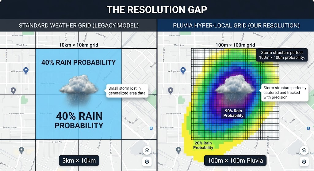
Global and regional numerical weather models (like the GFS or ECMWF) run on grids ranging from 9 kilometres to 25 kilometres. At that scale, an individual convective cell is physically smaller than a single grid box.
Because the model cannot "see" the storm directly, it has to approximate it using cumulus parameterization. It produces a statistical probability of rain smeared across a massive area, rather than pinpointing a specific location and time.
Even modern "convection-permitting" models—which run at finer grid spacings of 1 to 4 kilometres—still struggle. A 3-kilometre storm cell forming on a 3-kilometre grid simply does not resolve accurately, and these models still struggle with the compounding effect of multiple local triggers acting simultaneously.
This is the physical, not just practical, reason hyperlocal nowcasting exists. By fusing real-time radar reflectivity, satellite cloud-top imagery, and commercial microwave link (CML) data, tracking it at 100-metre resolution, and refreshing the calculations every 2 minutes, a nowcasting system represents the storm as the moving, evolving object it actually is.
5. The ITCZ and the Monsoon Trough: The Backdrop, Not the Forecast
Two synoptic-scale features set the seasonal stage for tropical convection across Southeast Asia:
- The Intertropical Convergence Zone (ITCZ): A globe-circling band near the equator where trade winds from both hemispheres converge, forcing air upward and sustaining a near-permanent belt of thunderstorm activity.
- The Monsoon Trough: A regional low-pressure zone that shifts with the Northeast and Southwest monsoon seasons, heavily modulating the total ambient moisture available.
Neither feature tells you where a storm will form on a given afternoon. What they do is set the budget of moisture and instability that local triggers draw on.
Think of the ITCZ and monsoon trough as the city water reservoir, and local triggers (sea breezes, heat islands) as the taps. The reservoir determines how much water is available globally; the taps determine exactly where and when the water is released. A forecasting system that relies only on tracking the reservoir will get the broad seasonal risk right, but it will get the specific timing and location wrong every single time.
6. A Tale of Two Cities: Comparing Convective Regimes
Making the contrast concrete clarifies the procurement criteria for operations leaders.
A city like London experiences rainfall that is overwhelmingly frontal. A cold front hundreds of kilometres long sweeps through, bringing six hours of steady, widespread, light-to-moderate rain to the entire metro area simultaneously. Forecasting that system at 10km resolution with hourly updates works reasonably well. The phenomenon is large and slow-moving relative to the grid.
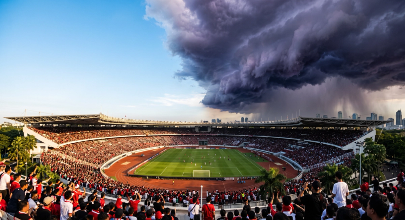
A city like Singapore or Jakarta experiences the opposite. On a typical convective afternoon, one district can be paralyzed by an intense 45-minute downpour while a logistics hub 8 kilometres away operates under clear skies. By evening, the roles can abruptly reverse.
Averaged over a month, both London and Singapore report their total rainfall accurately. But the operational reality on the ground could not be more different. Resolution and refresh rates that work perfectly well for temperate forecasting are structurally inadequate for tropical operations. Tropical weather is not "harder to model" in a vague sense; it is simply driven by phenomena that are physically smaller and faster. Your model must match that scale to be useful.
7. Integration: What Technical and Ops Teams Actually Need to Know
For product managers, data engineers, and ops leaders, the practical implication of tropical convective physics is that "resolution" and "refresh rate" are not just marketing buzzwords. They map directly to the physical reality of the hazard being forecast.
- Match your refresh rate to the storm's lifecycle: With convective cells maturing and dissipating in well under 90 minutes, an API that updates once an hour will entirely miss the birth and peak of a localized flash flood. An update cadence of every few minutes (like Pluvia's 2-minute refresh) is required to capture the storm's true trajectory.
- Match your spatial resolution to the trigger, not the district: Sea-breeze convergence lines and urban heat islands express themselves over hundreds of metres, not kilometres. A 100-metre grid is not a luxury upgrade; it is the practical floor required to distinguish between a flooded highway and a passable parallel route.
- Treat the monsoon as background risk, not a tactical forecast: Seasonal patterns tell you when your quarterly disruption risk is elevated. They do not tell you which concrete pour to halt at 3:00 PM on a Tuesday. Tactical stop/go decisions require deterministic nowcasts.
8. What Technical Evaluators Should Do Now
When evaluating a commercial weather data provider for Southeast Asian operations, cut through the noise with one question:
“What specific physical process does your model resolve, at what spatial grid scale, and how does your update cadence compare to the 30-to-90-minute lifecycle of a tropical convective cell?”
That single question filters out generic global weather APIs immediately. If the system is not built to track isolated, rapidly evolving 5km storm cells in near real-time, it is not built for Southeast Asia.
About Pluvia: Pluvia.ai provides hyper-local weather and flood prediction APIs purpose-built for Southeast Asia. Our platform delivers 100m resolution, 2-minute refresh rates, and physics-informed AI, validated against PUB, Singapore's national water agency. We empower organizations like Gojek to optimize millions of shifts across 31 cities, and protect mega-projects like Changi Airport Terminal 5. Contact us at contact@pluvia.ai or visit pluvia.ai to see how physics-informed nowcasting handles the storms that global models average away.
Call to action: See how Pluvia's radar-and-satellite nowcasting engine tracks convective storms as they actually form and move — Talk to us about an API pilot for your region.