
Key Takeaways:
- Two different paradigms: Nowcasting and traditional Numerical Weather Prediction (NWP) solve different mathematical problems. Nowcasting extrapolates what is happening right now using computer vision and sensor fusion, while NWP simulates the atmosphere's physical fluid dynamics forward from a starting snapshot.
- The Multi-Source Fusion Advantage: Relying solely on radar creates blind spots. Modern nowcasting engines fuse weather radar and geostationary satellite imagery with opportunistic ground truth: Commercial Microwave Links (CML) from telcos, IoT rain gauges, and CCTV feeds.
- Deep Learning over Optical Flow: Modern nowcasting systems use machine learning—specifically Convolutional Long Short-Term Memory (ConvLSTM) networks and deep generative models—trained on years of multi-sensor data to predict how a storm is growing or decaying, not just where it is moving. Pure optical flow extrapolation cannot do this.
- The Blended 180-Minute Curve: Because coarser NWP models struggle with initial "spin-up" time, AI nowcasting dominates the 0–90 minute window. NWP only becomes the dominant component once lead time extends beyond three hours.
- Verified Accuracy: By utilizing this blended, high-resolution approach, systems like Pluvia achieve a ~29% higher 15-minute Critical Success Index (CSI) compared to global machine learning baselines.
When an engineering team integrates a weather API into a dispatch platform or a routing engine, they are usually buying an assumption: that the data they receive is a mathematically sound representation of reality.
But in the first 0 to 3 hours of a forecast—the critical window for tactical operations like pausing a concrete pour or rerouting a delivery fleet—that assumption frequently breaks down. Most global weather APIs feed their users raw Numerical Weather Prediction (NWP) data. NWP is a miraculous scientific achievement for forecasting weather days in advance, but for street-level decisions happening right now, it is fundamentally the wrong tool for the job.
To achieve true, street-level accuracy in the 0–180 minute window, weather platforms must shift from physical simulation to spatial-temporal extrapolation. This is the domain of the AI-driven Nowcasting Engine.
1. Nowcasting vs. NWP: Two Different Mathematical Problems
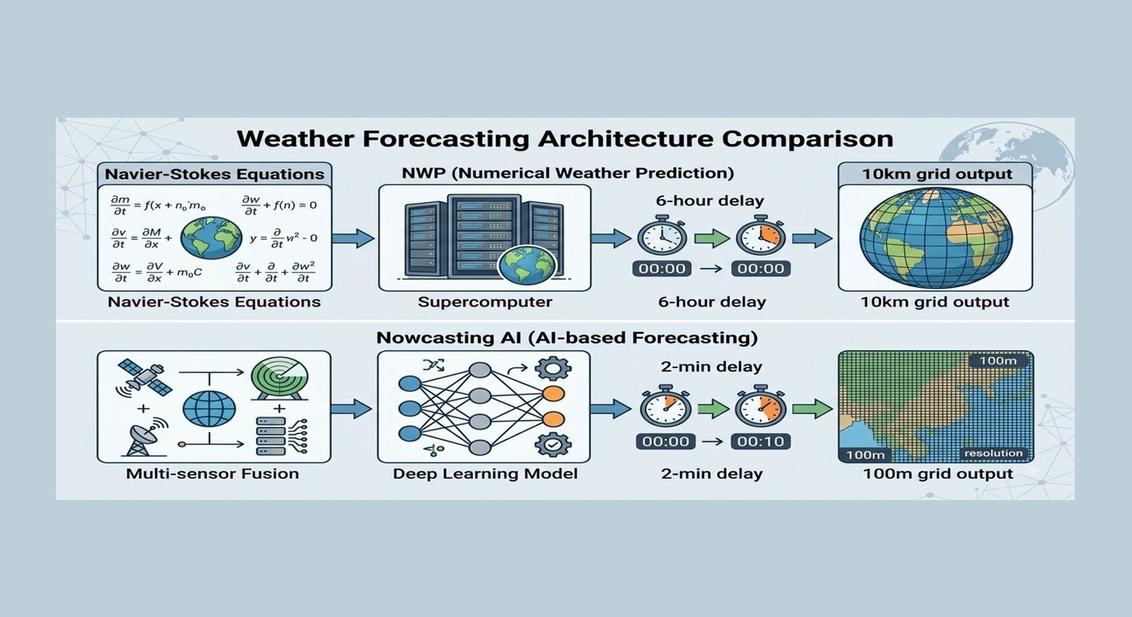
Numerical weather prediction works by solving the physical equations that govern the atmosphere (the Navier-Stokes equations). It starts from an initial snapshot built from global data, then integrates those equations forward on a supercomputer.
NWP is genuinely powerful for hours-to-days-ahead forecasting once weather patterns are large enough to be well represented on a 10km grid. But in the first one to three hours, it has a fatal structural weakness known as the "spin-up" problem. The small-scale details of an individual convective storm cell simply aren't well constrained by the model's starting conditions, and the model takes hours of compute time to generate a realistic representation of what's already happening on the ground.
Nowcasting solves a different problem entirely. Instead of simulating atmospheric physics from scratch, it treats weather as a sequence-to-sequence computer vision and sensor fusion problem. It starts from the most recent observations and asks: Given how this localized system has been moving and evolving over the last 60 minutes, where will it be in 10 minutes, 60 minutes, or 180 minutes? Because nowcasting bypasses heavy physical calculations in favor of pattern extrapolation, it can update in near real-time, matching the speed of fast-forming tropical storms.
2. Multi-Source Data Fusion: Moving Beyond the Radar
Historically, nowcasting relied entirely on weather radar. Radar emits pulses of microwave energy and measures the energy reflected back by raindrops (reflectivity). While powerful, radar has limitations: terrain blocks the beam, it suffers from "cone of silence" blind spots directly above the dish, and calibrating radar reflectivity to actual ground-level rainfall intensity (the Z-R relationship) is notoriously unstable in tropical climates.
To solve this, advanced nowcasting engines like Pluvia use Multi-Source Data Fusion. The AI model does not just ingest radar; it continuously assimilates multiple layers of atmospheric and opportunistic ground-truth data:
- Weather Radar & Geostationary Satellites: Satellites (imaging every 10 minutes) track cloud-top temperatures, serving as a proxy for how vigorously a storm is growing. This allows the model to flag "genesis" (updraft) stages before radar detects a single drop of rain.
- Commercial Microwave Links (CML): A major breakthrough in hydrometeorology. Telco cellular towers constantly transmit microwave signals to one another. When it rains, these signals are attenuated (weakened) by the falling water droplets. By ingesting CML signal data from telco networks, the AI gains tens of thousands of opportunistic, street-level precipitation sensors, filling the gaps between traditional radar coverage.
- IoT Rain Gauges & CCTV: Ground station rain gauges and visual data from traffic/CCTV networks provide absolute "ground truth."
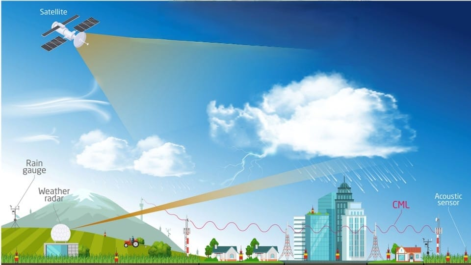
These ground-truth layers (CML, gauges, CCTV) are essential. They continuously bias-correct the radar and satellite estimates in real-time. If the radar thinks 50mm of rain is falling, but the local CML attenuation and rain gauges report only 15mm, the AI dynamically calibrates the nowcast to reflect reality on the asphalt.
3. Why AI, Not Simple Extrapolation?
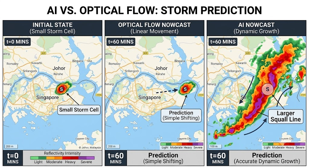
Early nowcasting systems did not use AI. They relied on "Optical Flow" algorithms, which take the current radar pattern and simply advect it forward, assuming a constant speed and trajectory.
This approach degrades precipitously after 20 minutes. Optical flow cannot represent growth, decay, splitting, or merging. If a storm is expanding rapidly due to an urban heat island, optical flow just moves the existing small storm forward linearly.
Modern systems abandon pure optical flow for deep learning. By utilizing Convolutional Long Short-Term Memory (ConvLSTM) networks and Deep Generative Models trained on years of historical multi-sensor data, the model learns the spatial-temporal lifecycle of a storm. The AI learns not just where a pixel is moving, but how storms of this specific shape and intensity typically evolve over the local terrain.
4. Blending Nowcast and NWP Across the 0–180 Minute Window
Neither nowcasting nor NWP wins across the entire operational timeline. Because they excel at different things, a production-grade forecasting engine must blend the two.
- 0 to 90 Minutes: Nowcasting dominates. Extrapolation from the latest multi-sensor imagery stays vastly more accurate than a physics-based simulation for as long as the near-term picture is dictated by what's currently on the radar screen.
- 90 to 180 Minutes: The crossover zone. The accuracy of extrapolation decays as existing storms die out and completely new storms form. The system smoothly shifts weight from the Nowcast to the NWP model.
- 180+ Minutes: NWP takes over. Larger-scale atmospheric dynamics (pressure systems, prevailing winds) start to matter more than the life-cycle of any single, pre-existing storm cell.
A well-built system blends the two with a continuously shifting probabilistic weight rather than a hard cutover, avoiding a visible "seam" where an API’s forecast would otherwise jump wildly at the three-hour mark.
5. Where Model Skill Actually Breaks Down
No nowcasting system is uniformly reliable across every edge case, and knowing the weak spots matters as much as knowing the strengths.
Clear-air initiation is a notorious boundary case. When a storm forms over an Urban Heat Island from clear air in under 15 minutes, there is no pre-existing radar echo to extrapolate from. Early lead time in these cases leans heavily on satellite-based genesis signals and the ground-truth network (CML and gauges) detecting the very first drops.
The practical response for an engineering team is to request quantified performance separately for these edge cases. A provider that reports a single, generic blended accuracy figure is averaging away exactly the failure modes that matter most operationally.
6. Integration: What Engineering Teams Actually Need to Know
For product and engineering teams integrating a nowcasting API into an operational platform, the underlying architecture translates into a concrete procurement checklist:
- Ask about data ingestion, not just modeling. A great AI model running on uncalibrated radar data will produce bad forecasts. Ask if the provider assimilates CML, IoT gauges, or CCTV data to bias-correct their radar in real-time.
- Ask which lead times are nowcast-driven vs. NWP-driven. A provider must be able to state plainly where their blending curve crosses over, so you know which part of your 0–180 minute window is reliable enough for automated tactical decisions.
- Check the update cadence against your decision loop. If your routing logic re-evaluates every 5 minutes, an API that only refreshes every 60 minutes is throttling your system's responsiveness. Look for sub-5-minute refresh rates.
- Confirm the spatial resolution. Nowcasting an isolated tropical storm cell on a 10km grid is computationally pointless. The API output must operate at 100m to 500m resolution to be actionable at the street level.
7. What Product Leaders Should Do Now
When evaluating weather APIs, request the provider's actual skill scores (Probability of Detection, False Alarm Rate, and Critical Success Index) broken down by lead time at 15, 60, and 180 minutes.
About Pluvia: Pluvia.ai provides hyper-local weather and flood prediction APIs purpose-built for Southeast Asia. Our infrastructure delivers 100-metre resolution and 2-minute refresh rates using physics-informed AI and multi-source data fusion (Radar, Satellite, CML, and Gauges). Validated independently against agencies like Singapore's PUB, Pluvia achieves a ~29% higher 15-minute Critical Success Index (CSI) than global machine learning baselines.
Call to action: See how Pluvia's multi-sensor nowcasting engine blends with NWP across the 0–180 minute window to protect logistics, aviation, and construction fleets. Request a Pluvia Pilot for your Company .