

Key Takeaways:
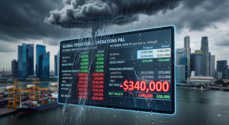
- The scale of disruption: The 2024–2025 monsoon season brought unusual clarity to the cost of weather disruptions, with severe flooding across Southeast Asia (compounded by events like Typhoon Yagi) causing combined economic losses of nearly $15 billion.
- The resolution gap: Standard weather APIs deliver data at 1km–5km resolution; hyperlocal APIs like Pluvia's operate at 100 meters. This is the difference between seeing a flooded 500-meter corridor and seeing "partly cloudy" for the whole district.
- The ROI of prediction: In the U.S., weather is responsible for 23% of all roadway delays, costing the trucking industry an estimated up to $3.5 billion annually (Federal Highway Administration). Although equivalent data for SEA is hard to come by, the financial toll is proportionally greater given the severity of monsoon seasons.
- Seamless integration: Integration is REST/JSON-based and plugs directly into existing TMS, WMS, driver-app, and customer-communication systems without requiring a platform overhaul.
Southeast Asia's logistics sector moves at a relentless pace. Across the region's archipelagos, river deltas, and dense urban corridors, freight networks are under constant pressure from one variable that no amount of operational efficiency can eliminate: weather.
The 2024–2025 monsoon season illustrated the stakes with unusual clarity. A series of extreme weather events, culminating in Typhoon Yagi, brought rainfall totals described as "unseen in decades" and caused combined economic damages approaching $15 billion in the region. These events severed supply chains that had taken years to optimize, stranding fleets and delaying critical deliveries.
For logistics operations managers in Southeast Asia, these events are not rare exceptions. They are the baseline operating environment. The question is no longer whether weather will disrupt logistics in Southeast Asia. It is whether your operation is using the right data to anticipate it.
The Resolution Problem: Why Standard Weather Data Fails SEA Logistics
Most logistics companies that use weather data today rely on one of three sources: national meteorological services, free global APIs, or manual weather checks by dispatchers. Each has a fundamental limitation when applied to last-mile operations in Southeast Asian cities: resolution.
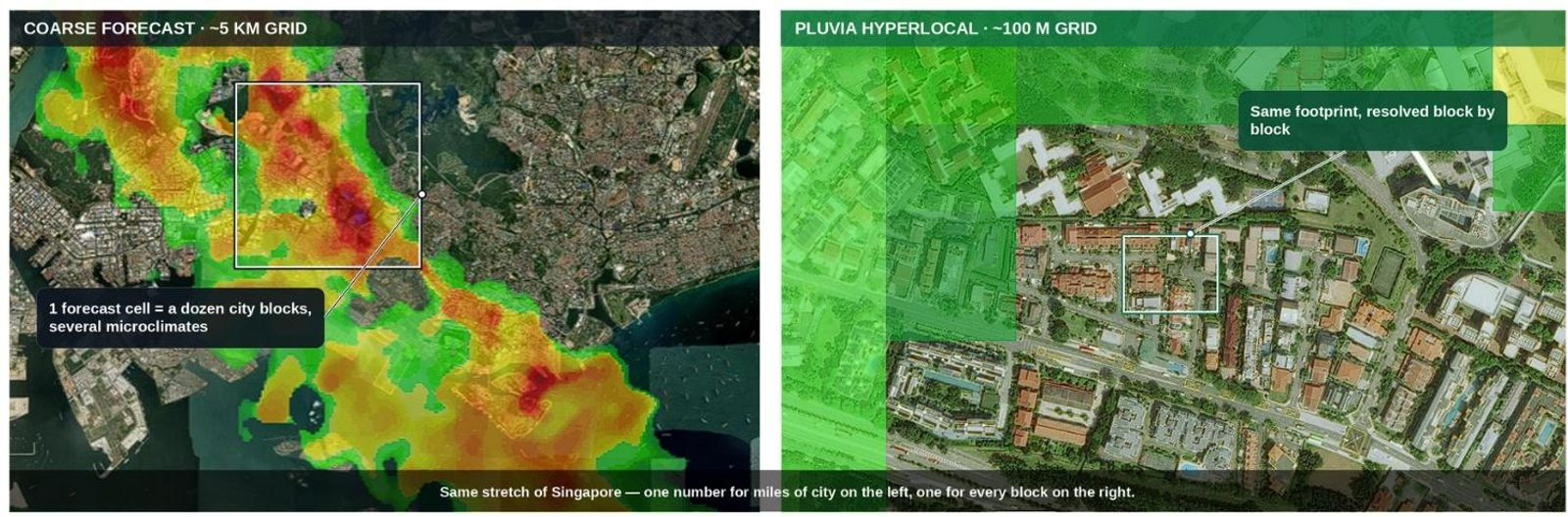
A national weather station may be accurate for the broad district it measures. But rainfall in Southeast Asia—particularly in cities like Bangkok, Jakarta, Ho Chi Minh City, and Kuala Lumpur—does not behave at the district level. Much of the region's rainfall comes from convective storms: intense, short-lived, and highly localized. A storm cell can drench a 500-meter corridor while leaving adjacent streets completely dry. Flash floods triggered by a 30-minute downburst can make a delivery route impassable for two hours, then recede entirely—while your regional forecast simply shows a "60% chance of rain".
Standard global weather APIs typically deliver data at 1km to 5km resolution. For urban logistics, that coarse resolution obscures the very events that cause delays. Hyperlocal weather APIs, however, deliver data at resolutions as fine as 100 meters, updated in near real-time. At that scale, the difference between a passable road and a flooded one becomes visible in the routing engine before it ever becomes a problem for your driver on the ground.
The Business Case: What Monsoon Disruptions Actually Cost
The cost of weather-related logistics delays is no longer abstract. In the mature US market, the Federal Highway Administration reports that weather is responsible for roughly 23% of all roadway delays, costing the trucking industry an estimated $3.5 billion annually.
In Southeast Asia, where monsoon seasons are longer, more intense, and increasingly amplified by climate change, the baseline disruption is proportionally more frequent and more severe. According to the July 2025 Natural Catastrophe Review by Willis Towers Watson (WTW), global insured losses from natural catastrophes now consistently exceed $100 billion per year. The report specifically flags compound events and climate extremes as a new era of risk. A significant share of those losses flows directly through logistics disruption: delayed shipments, cargo spoilage, failed deliveries, emergency rerouting costs, and customer attrition.
While region-specific ROI metrics for predictive weather intelligence are still emerging, industry data highlights clear potential. Businesses optimizing their operations based on proactive weather insights frequently observe substantial improvements in efficiency, customer satisfaction, and on-time delivery performance. In a tropical monsoon environment, the upside of predictive data is arguably much higher.
How a Hyperlocal Weather API Enables Proactive Logistics Operations
The shift from reactive firefighting to proactive operations is where weather API integration delivers its clearest return.
- 24–48 hours before a weather event: The Pluvia Weather and Flood Prediction API flags elevated flood risk across specific route segments based on rainfall forecasts at 100m resolution. Operations teams receive automated alerts through webhook integration with their transport management system (TMS). Shipments scheduled for affected corridors are rerouted or rescheduled before drivers even depart the depot.
- 2–6 hours before: Near-real-time flood prediction data refines the risk picture. Which roads are passable? Which last-mile delivery zones are likely to become inaccessible? Dispatchers adjust live routes accordingly and trigger proactive customer notifications—turning a frustrating surprise into a managed expectation.
- During the event: Drivers receive live updates through integrated mobile alerts. Supervisors monitor fleet positions against a live flood risk overlay. Decisions about holding freight at intermediate depots versus pushing through can be made on data, not instinct.
- After the event: Historical weather event data supports incident reporting, contract dispute documentation, and insurance claims. For operations running parametric risk products, the same data that triggered alerts can trigger financial instruments automatically.
Vendor Comparison: Not All Weather APIs Are Built for the Tropics
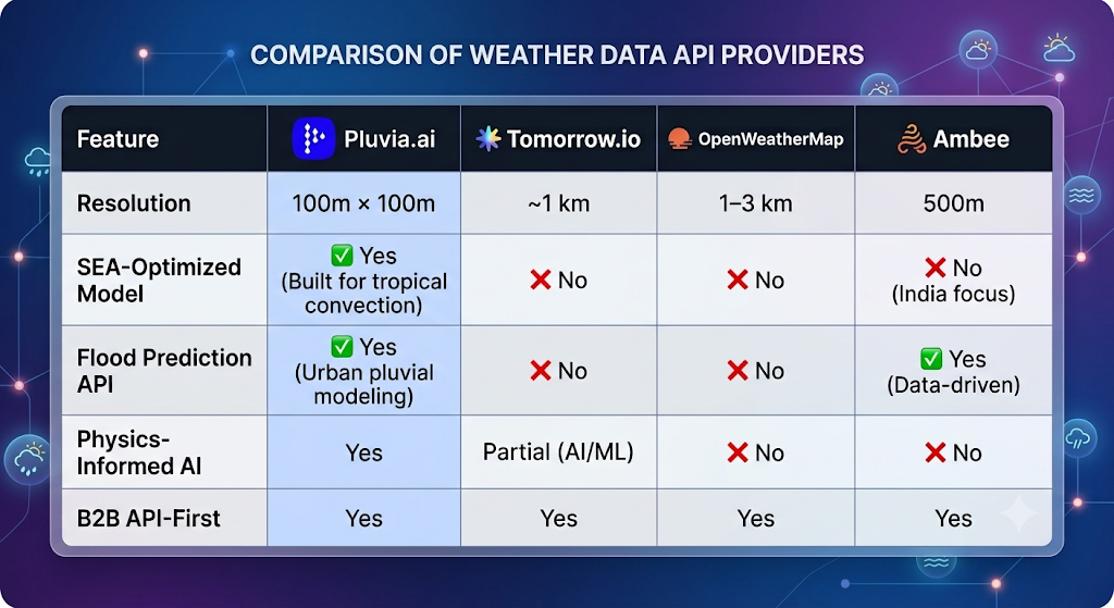
When evaluating vendors, the questions that matter most for Southeast Asian operations are resolution (can the API distinguish a single city block?), update frequency (minutes vs. hours?), and regional specificity (is the model trained on equatorial convective storms, or adapted from Western climates?).
Below is a breakdown of how the major API providers compare for Southeast Asian logistics use cases:
Integration: What Logistics Teams Actually Need to Know
Implementing a weather API for logistics does not require a major infrastructure overhaul. The Pluvia API is designed for integration into existing operational software stacks via standard REST API endpoints with JSON output. SDKs for Python, Node.js, and Java make it seamless for engineering teams to adopt.
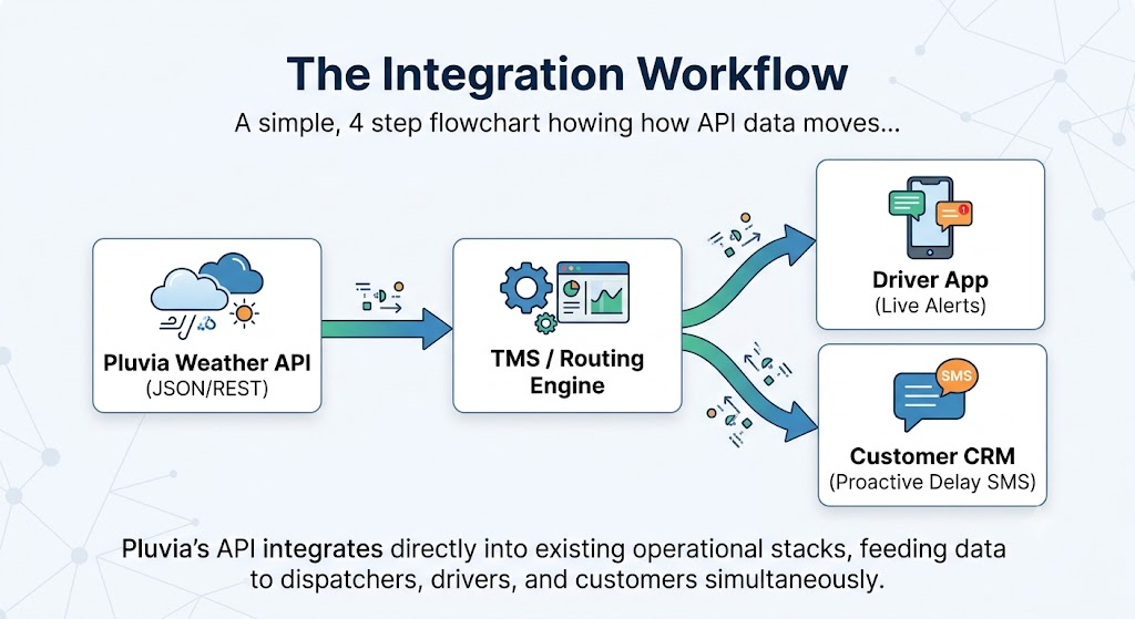
The key integration points are:
- TMS Integration: Feeding weather risk scores into route optimization at the planning stage.
- WMS Integration: Linking inbound shipment risk to receiving schedules.
- Driver-App Integration: Pushing real-time, route-specific alerts directly to fleets.
- Customer Communication Systems: Automating delay notifications triggered by exact weather thresholds, ensuring the customer hears from you before they notice a delay.
What Logistics Leaders Should Do Now
The weather API market is consolidating around providers with hyperlocal data, regional expertise, and enterprise-grade uptime guarantees. For logistics companies operating across Southeast Asia, the window to build a competitive advantage through weather intelligence is open, but it will not remain so indefinitely.
The companies that move first on proactive, data-driven weather operations will deliver better customer experiences, significantly reduce operating costs, and build the operational resilience that increasingly defines supply chain quality in the region.
The monsoon does not wait. Neither should your data.
About Pluvia: Pluvia.ai provides hyper-local weather and flood prediction APIs purpose-built for Southeast Asia. Contact us at contact@pluvia.ai or visit pluvia.ai to learn how our 100m-resolution forecasts and physics-informed flood models can integrate with your logistics operations.
Call to action: Request a sample dataset or a trial API key — contact@pluvia.ai.
Frequently Asked Questions (FAQ)
What weather parameters can be monitored via the API?
Pluvia's core focus is rainfall intensity and rainfall probability. Alongside rainfall, Pluvia also provides temperature, wind speed, and atmospheric pressure to give logistics teams a complete operational picture. For flood-prone routes, Pluvia models water risk by simulating flow and accumulation at the street level.
How often is the weather data updated?
Data refreshes every 2 minutes, ensuring rapid response to fast-forming tropical storms. There is a minimal 5-minute latency between real-world measurement and API availability.
What geographic locations does Pluvia cover?
Pluvia's 100m × 100m resolution API covers major markets across Southeast Asia and beyond, including Singapore, Malaysia, Indonesia, Thailand, the Philippines, Vietnam, Taiwan, and Croatia.
How hard is it to integrate the API into an existing TMS/WMS?
Integration is highly straightforward. The Pluvia Rain API is a standard REST API that returns structured JSON responses. We also provide dedicated developer SDKs for Python, Node.js, and Java, meaning it plugs directly into existing dispatch and operational tools with minimal engineering lift.
Can I test the API before committing to an enterprise plan?
Yes. Pluvia offers a Free API tier that provides up to 10,000 calls to help your engineering team validate the integration. This tier includes the exact same 100m resolution, 2-minute refresh rate, and 5-minute latency as our paid enterprise plans, valid for two weeks with no credit card required.