
Key Takeaways:
- The MAUSAM Benchmark: A 2025 Stanford-led study, MAUSAM (Measuring AI Uncertainty during South Asian Monsoon), benchmarked seven leading global AI weather models—FourCastNet, FourCastNet-SFNO, Pangu-Weather, GraphCast, Aurora, AIFS, and GenCast—against real weather stations, rain gauges, and satellite imagery across the South Asian monsoon, rather than against the reanalysis data most leaderboards use.
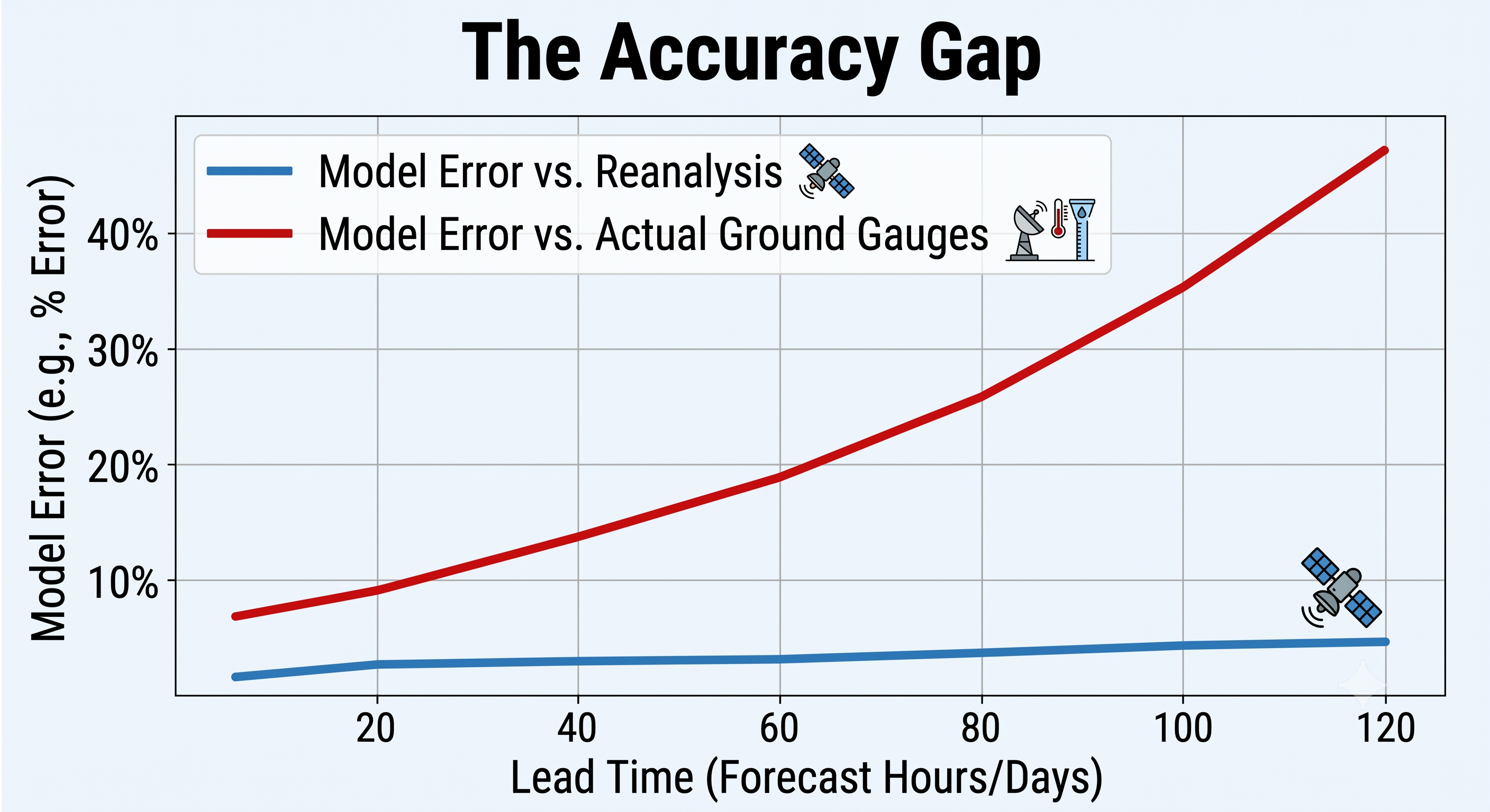
- The Reanalysis Mirage: Grading against real observations instead of reanalysis raised every model's error by 15–45%, with the gap widening at longer lead times. This is clear evidence that reanalysis-centric benchmarks routinely overstate how good these models actually are on the ground.
- The Mesoscale Deficit: The same models that reproduce large-scale atmospheric physics convincingly still systematically underestimate mesoscale kinetic energy and extreme rainfall. These are precisely the scales that determine flooding, delivery delays, and site shutdowns in Southeast Asia.
- Our Regional Validation: Pluvia's own verification across 77 regional gauges in July 2026 shows the exact same pattern: newer, more heavily promoted global AI models frequently trail both leading AI competitors and the decades-old GFS model on short-range precipitation accuracy in the tropics.
- The Ground-Truth Necessity: Global model sophistication doesn't automatically transfer into tropical, hyperlocal accuracy. Bias-correcting against local ground truth—not just blindly adopting the newest AI model—is what actually closes the operational gap.
Over the last three years, the meteorology and tech sectors have been captivated by the rise of global AI weather models. Machine learning architectures like Google DeepMind’s GraphCast, Huawei’s Pangu-Weather, and ECMWF’s AIFS have rapidly climbed global leaderboards, frequently beating traditional, physics-based supercomputer models (NWP) on standard accuracy metrics.
For operations leaders in logistics, aviation, and construction, this raises an immediate, practical question: Should we swap our existing weather data for the newest global AI model?
Before making that switch in Southeast Asia, technical evaluators must look beyond the global leaderboards. A breakthrough 2025 study from Stanford University researchers Aman Gupta, Aditi Sheshadri, and Dhruv Suri—titled MAUSAM: An Observations-focused assessment of Global AI Weather Prediction Models During the South Asian Monsoon—reveals a stark reality. When tested against actual ground-truth observations in a tropical convective regime, the world’s best AI models still systematically struggle with the fast-forming, extreme weather events that cause the most severe disruptions.
1. Why the Monsoon Makes a Brutal Test Case
The Stanford team built MAUSAM to test seven of the field's most cited AI weather models: FourCastNet, FourCastNet-SFNO, Pangu-Weather, GraphCast, Aurora, AIFS, and GenCast.
Crucially, they did not test these models globally. They evaluated them through the South Asian monsoon. The monsoon is a deliberately harsh proving ground. It is governed by the same interplay of fast-moving convective storms, intense moisture, land-ocean coupling, and localized topography that defines tropical weather across Southeast Asia. The model physics required to predict a monsoon downpour in Kerala are identical to the physics required to predict a flash flood in Jakarta, Bangkok, or Manila. The MAUSAM findings serve as an exact proxy for what these global models face in Southeast Asia.
2. The Reanalysis Mirage
To understand why the Stanford findings are disruptive, you must understand how weather AI is typically graded.
Most public benchmarks grade AI weather models against ERA5. ERA5 is a "reanalysis" dataset produced by feeding decades of historical observations through ECMWF's own forecasting model to create a pristine, complete, historical grid of the world's weather. It is convenient, global, and high-resolution.
However, ERA5 is itself a model output, not absolute ground truth. Furthermore, nearly every AI weather model in the field was trained on ERA5 data. Testing an AI model against the exact same reanalysis data it learned from is essentially grading an open-book exam.
When the MAUSAM researchers discarded the ERA5 benchmark and instead validated the seven models against 458 real ground-based weather stations, rain gauge networks, and geostationary satellite imagery, the illusion of near-perfect accuracy cracked. Forecast errors were 15–45% larger across the board compared to observations than they were when compared to reanalysis. For a two-week-ahead forecast, the gap widened to roughly double what the reanalysis-based scoring suggested.
3. Where Accuracy Breaks Down: Mesoscale Energy and Rainfall Extremes
The MAUSAM study utilized spectral analysis across all seven models, revealing a systematic underestimation of kinetic energy at mesoscale wavenumbers—roughly the 1 to 100 kilometre spatial range.
This is the exact spatial range that governs individual convective storm cells and squall lines. While GenCast was a notable exception, tracking the energy spectrum closely, most of the global AI models simply lack the kinetic energy at the storm scale that the real atmosphere possesses.
This energy deficit translates directly into operational misses. Compared against actual monsoon rain gauges, all the models tested overestimated light-to-moderate rain while severely underrepresenting the heavy end of the distribution (daily accumulations above 50mm). These are the exact events that actually cause floods. While GraphCast performed exceptionally well on large-scale variables, it underestimated these extreme rainfall tails most severely. (AIFS, conversely, exhibited the most consistent representation of atmospheric variables and rainfall tails among the deterministic models).
4. The Resolution and Refresh-Rate Ceiling
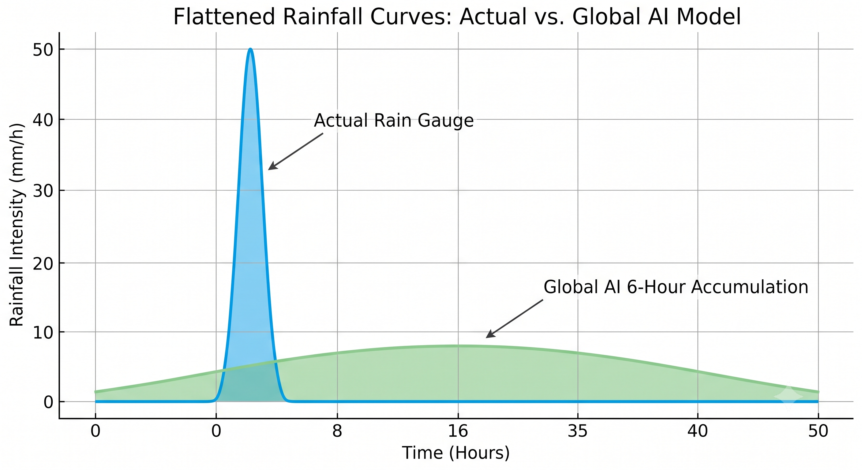
The underlying reason for these misses is architectural. The global models in the study were generally trained on 25-kilometre resolution data, updated every 6 hours. For tropical convection—where a storm forms, peaks, and dissipates in 90 minutes across a 5km footprint—this creates a hard ceiling on accuracy.
The MAUSAM study highlighted several concrete, operationally relevant misses due to this ceiling:
- Heatwave miscalculations: During Delhi's severe May 2022 heatwave, AIFS underpredicted peak afternoon temperatures by a massive 5°C, and its wind-speed forecasts bore little resemblance to what was actually observed at the surface.
- Flattened rainfall: Six-hourly rainfall accumulation constraints flattened an extreme, violent monsoon burst over Kochi into a smooth, gentle curve that completely missed the sharp, localized flooding spike ground stations recorded.
- Divergent cyclone tracks: For cyclones Tauktae and Yaas, model trajectories issued seven days ahead of landfall spread by up to 10 degrees of latitude. One model's week-ahead forecast implied neither storm would make landfall over India at all.
5. Our Own Numbers Tell the Same Story
At Pluvia, we ran a parallel validation check closer to home. We tracked 12-hour precipitation accumulation against 77 regional rain gauges across Southeast Asia over a highly volatile one-week window (16–22 July 2026). We compared the long-standing GFS model, ECMWF's AIFS, and Google's highly promoted WeatherNext 2 model across forecast lead times.
The results mirrored the Stanford MAUSAM findings entirely. AIFS held the steadiest, generally lowest deterministic error (CRPS/MAE) across the lead times. GFS was noisier at short lead times but sharpened further out. WeatherNext 2—despite being the newest AI model of the group—posted the highest CRPS error at every lead time in our window, with the accuracy gap widening the further out the forecast extended.
While one region and one week is a directional read rather than a permanent ranking, the operational reality is clear: a global model's architecture, massive parameter count, and training scale do not automatically translate into better regional, gauge-level accuracy in the tropics.
6. What This Means for How Pluvia Builds Forecasts
This research validates why Pluvia does not bet its operational accuracy on any single global AI model.
We treat global AI and NWP backbones as a starting field, not a finished product. We then continuously bias-correct those models against Southeast Asian ground truth—IoT rain gauges and validated networks like PUB, Singapore's national water agency. We run our localized outputs at 100-metre resolution, refreshed every 2 minutes, blending in deep-learning nowcasting for the short lead times where AI extrapolation easily beats any global model's spin-up time.
It is the exact discipline the MAUSAM authors argue for: validate against local observations before trusting a model operationally, not just against the global data it was trained on.
7. Integration: What Engineering and Data Teams Actually Need to Know
Turning this research into a procurement checklist for your routing and operations teams means asking weather data providers to show their work.
- Ask what ground truth a provider validates against: A reanalysis-only (ERA5) accuracy claim should be heavily discounted. MAUSAM proved errors are 15–45% higher against real stations.
- Don't equate a newer or larger model with better regional accuracy: Request a head-to-head comparison against your specific region's gauges, not a rank on a global leaderboard.
- Ask for tail-event verification: Mean-error scores look fine while hiding a systematic underestimation of the heavy, fast-forming rain that actually causes floods. If your thresholds depend on rainfall extremes, demand to see accuracy data for >50mm events.
8. What Product and Engineering Leaders Should Do Now
The next time you evaluate a weather API for Southeast Asia, request their error figures against your own region's rain gauges and weather stations. Treat any provider that cannot produce that local, ground-truth comparison as unverified for your operating area.
About Pluvia: Pluvia.ai provides hyper-local weather and flood prediction APIs purpose-built for Southeast Asia. We deliver 100-metre resolution and near real-time refresh rates using physics-informed AI, heavily bias-corrected and validated against regional ground truth, including PUB, Singapore's national water agency. Visit pluvia.ai to see how ground-truth-calibrated forecasting performs in your operating region.
Call to action: Stop trusting generic global benchmarks. Talk to us about benchmarking Pluvia's 100m forecasts against your own operational sites and gauges — Contact Pluvia Support.